


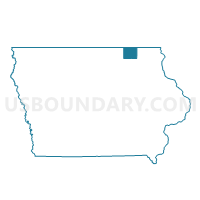
ALBION TWP Voting District, Howard County, Iowa
About
Outline

Summary
| Unique Area Identifier | 582333 |
| Name | ALBION TWP Voting District |
| County | Howard County |
| State | Iowa |
| Area (square miles) | 29.47 |
| Land Area (square miles) | 29.47 |
| Water Area (square miles) | 0.00 |
| % of Land Area | 100.00 |
| % of Water Area | 0.00 |
| Latitude of the Internal Point | 43.46486700 |
| Longtitude of the Internal Point | -92.13918250 |
Maps


Graphs
Select a template below for downloading or customizing gragh for ALBION TWP Voting District, Howard County, Iowa


Neighbors
Neighoring Voting District (by Name) Neighboring Voting District on the Map
- Bristol Twp. Voting District, Fillmore County, MN
- FOREST CITY TWP Voting District, Howard County, IA
- FREMONT TWP Voting District, Winneshiek County, IA
- Harmony Twp. Voting District, Fillmore County, MN
- HOWARD CENTER TWP Voting District, Howard County, IA
- ORLEANS TWP Voting District, Winneshiek County, IA
- VERNON SPRINGS TWP Voting District, Howard County, IA
Top 10 Neighboring County Subdivision (by Population) Neighboring County Subdivision on the Map
- Vernon Springs township, Howard County, IA (4,540)
- Forest City township, Howard County, IA (768)
- Bristol township, Fillmore County, MN (396)
- Harmony township, Fillmore County, MN (387)
- Albion township, Howard County, IA (335)
- Orleans township, Winneshiek County, IA (289)
- Howard Center township, Howard County, IA (232)
- Fremont township, Winneshiek County, IA (220)
Top 10 Neighboring Unified School District (by Population) Neighboring Unified School District on the Map
Top 10 Neighboring State Legislative District Lower Chamber (by Population) Neighboring State Legislative District Lower Chamber on the Map
Top 10 Neighboring State Legislative District Upper Chamber (by Population) Neighboring State Legislative District Upper Chamber on the Map
Top 10 Neighboring 111th Congressional District (by Population) Neighboring 111th Congressional District on the Map
Top 10 Neighboring Census Tract (by Population) Neighboring Census Tract on the Map
- Census Tract 9501, Winneshiek County, IA (3,614)
- Census Tract 9605, Fillmore County, MN (3,266)
- Census Tract 9602, Howard County, IA (2,856)